 The growth rate in the copses varied due to different nutrient levels in the clay/shale soils and some poor drainage. This favoured the pioneer species that had grown to dominate many areas and threatened the survival of slower growing species. The positive side of that situation was that a reasonable degree of cover was formed at an early stage. That was particularly fortunate because the planted hedgerows have been patchy in their performance with many gaps arising from failure or flooding, and consequently they provided little habitat benefit.
A small patch of more mature small trees and a larger area of mixed age trees exist. These were on the perimeter of the open-cast mining operations. A largely Crataegus monogyna boundary hedge is also of significant age but had suffered from lack of maintenance and had few plant species at its base, which had become open and barren. Three mature field hedgerows join this boundary hedge to form an important corridor to open country to the south. Domestic properties along the NE boundary have large gardens and the remnants of hedgerows that originally formed most of their boundaries.
Meadows were cut on an urban park basis, limiting their habitat value. Some crescents of dedicated wildflower areas provided cover. These were cut twice yearly. In the early years after the site formation, skylarks nested, but that ceased as the number of visitors with loose dogs increased.
Drainage within copses is by open ditch feeding into culverts that accumulated the water to a feeder ditch for the Small Pond. Whips were planted up close to the ditch sides and as they grew they provided some cover to the ditches. Subsequently, for maintenance access, these saplings were cut out, leaving an unprotected strip either side of ditches. Ditches generally had standing water for eight months of the year because of culvert blockages. Culvert clearance in 2008 reduced the incident of standing water to just the winter period.
The system of meadow drainage was uncertain. Indications suggested porous land drains dispensing into the ditches and the culverts that connect the ditches. Uneven settlement of the fill material resulted in surface pooling in most meadow areas. Despite the cutting regime, grass species more appropriate to wet conditions established in clumps on the meadow areas most affected.
Water accumulated in the Small Pond from the site drainage was meant to flow via a ditch and a culvert into the Large Pond. The overflow from the Large Pond empties into the areas storm drainage system.
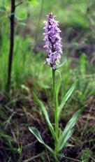 Settlement in the area of the Small Pond and a drastic reduction in water reaching that area gradually led to the water body shrinking and physically moving sideward. In the summer period the pond dried out. The flora reflected that change and southern marsh orchid established. Unfortunately Broxtowe decided to re-establish permanent water in this area and took Notts. Wildlife advice to create ‘scrapes’. That action dramatically changed what had been a natural formed habitat, with the loss of several wildflower species. The scrape was formed as just one sinking to a depth greater than advised. It remained dry for most of the year.
Broxtowe decided on a second attempt. This involved raising an earth bund around the scrape and installing a sluice gate in order to retain more water during the wet periods, and then control release it to flow to the Large Pond when required to maintain that ponds water level. The scrape quickly reverted to a seasonal Small Pond that still remained dry for most of the year and did not provide water to the Large Pond. This area was the subject of more careful thought as part of the water management review required by the Management Plan issued in January 2008.
Water level variation was the main factor in the Large Pond’s environment. Substantial shrinkage occurred and this impacted on the survival of the aquatic and marginal plantings. Maintenance of the water level was also required for public convenience. Dipping platforms stood high-and-dry during much of the period when they could have been of most benefit. The pond has always been a focus for visitors who fed the waterfowl and enjoyed the environment when a wide margin of mud was not present. Rectification proposals were included as part of the overall water management proposal.
The brook from the magnesian limestone area at High Park Wood flows under the B600 into a small area of the site with mixed age trees and substantial understorey growth. Seasonally, the brook floods parts of the adjacent domestic properties land. This mature area supports a greater range of species than elsewhere at Colliers Wood. The brook is culverted to the areas stormwater drainage system shortly after entering the site